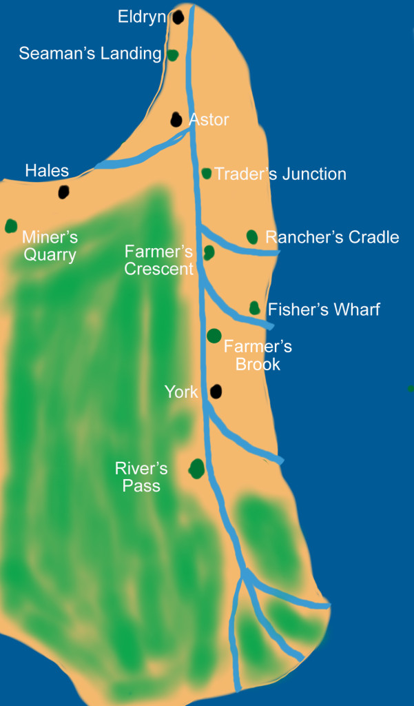
One of the questions I’ve been asked most often since I released The Healer’s Pact is: “What does the fictional world look like?” It’s a great question, and one that I’d love to put to rest with some cartography software. Unfortunately that stuff is expensive, so I’ll have to sell many, many, many books first.
Still, here’s a basic overview of the world of Camia, and then, after the jump I’ll include a sketch of Camia I made over two years ago.
***SPOILER ALERT: If you haven’t read From Death, the map contains a pretty crucial plot twist. Go read the book and then come back. Don’t say I didn’t warn you.***
Camia’s layout is pretty simple: the Eldryn River runs north-south through the land, and most of the capital cities and villages sit on the river or on it’s veins. Eldryn, the most populous city and the seat of King Corwan is the northernmost point, while the small village of River’s Pass is the southernmost point.
The Capital Cities: These are the most populated lands in Camia. There are four of them: Eldryn, Astor, Hales and York. The first three are in the northern part of Camia, while York is in the south.
The Villages: Each village is named after its primary good. Farmer’s Crescent and Farmer’s Brook are obviously farming villages. Rancher’s Cradle provides cattle. Miner’s Quarry is where encircling crystals are mined, Fisher’s Wharf, River’s Pass, and Seaman’s Landing deal with fish. Trader’s Junction is a trade outpost.
And with that said, here’s Camia as I imagined it back in 2012. Those of you that have already finished From Death should notice something interesting down south.

